

The first automatic aerial photographing over Nishinoshima Island by an Unmanned Aerial Vehicle
Outline Geospatial Information Authority of Japan (GSI) carried out aerial photographing over Nishinoshima Island by an Unmanned Aerial Vehicle (UAV*1) with cooperation of Ministry of Defense and Ogasawara Village on March 22nd. This is the first attempt of automatic photographing over isolated islands by a UAV in Japan. The UAV flew from Chichijima Island, 130 km far from Nishinoshima Island, took vertical photographs, and recorded its positions by a GNSS*2 receiver.
Details The aerial photographs, ortho mosaic image, DEM (digital elevation model), topographic interpretation maps, and other related data have been published on the Internet, as with the previous photographing by the manned aerial vehicle Kunikaze III on December 4th, 17th, 2013, and February 16th, 2014.
Though the photographing did not use camera and GNSS receiver for professional survey, we obtained enough results referring the formerly observed data by the Kunikaze III. GSI will try to use UAV to acquire geospatial information over isolated islands and hazard area. An outline of the measurements is provided below. 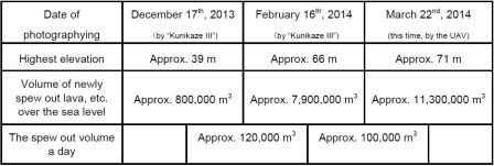 Attachments
Reference
 Some files are available in PDF format. To view PDF files, Adobe System's free "Adobe Reader" software must be installed. Please visit the following link to download the free software. |