

Active Fault Map in Urban Area officially announced for Eastern Boundary Fault Zone of the Yokote Basin/ Futaba Fault Zone/ Northwestern Boundary Fault Zone of the Kanto Plain
-Showing detailed positions of active faults based on latest expertise- On November 1st, 2013, Geospatial Information Authority of Japan (GSI) officially announced seven new Active Fault Maps in Urban Area, covering “TAZAWAKO”, “YOKOTE” and “YUZAWA” (in the Eastern Boundary Fault Zone of the Yokote Basin and its vicinity); “WATARI”, “SOUMA” and “MINAMISOUMA” (in the Futaba Fault Zone and its vicinity); and “TAKASAKI” (in the Northwestern Boundary Fault Zone of the Kanto Plain and its vicinity). (Attachment 1-1), (Attachment 1-2), (Attachment 1-3)
The Active Fault Map in Urban Area extracts active faults by aerial photo-interpretation, etc., compiling detailed locations of faults and directionality of slip, etc. in 1:25,000 scale topographic maps, and the seven newly released maps bring the total number of such maps to 163 nation-wide. (See below) 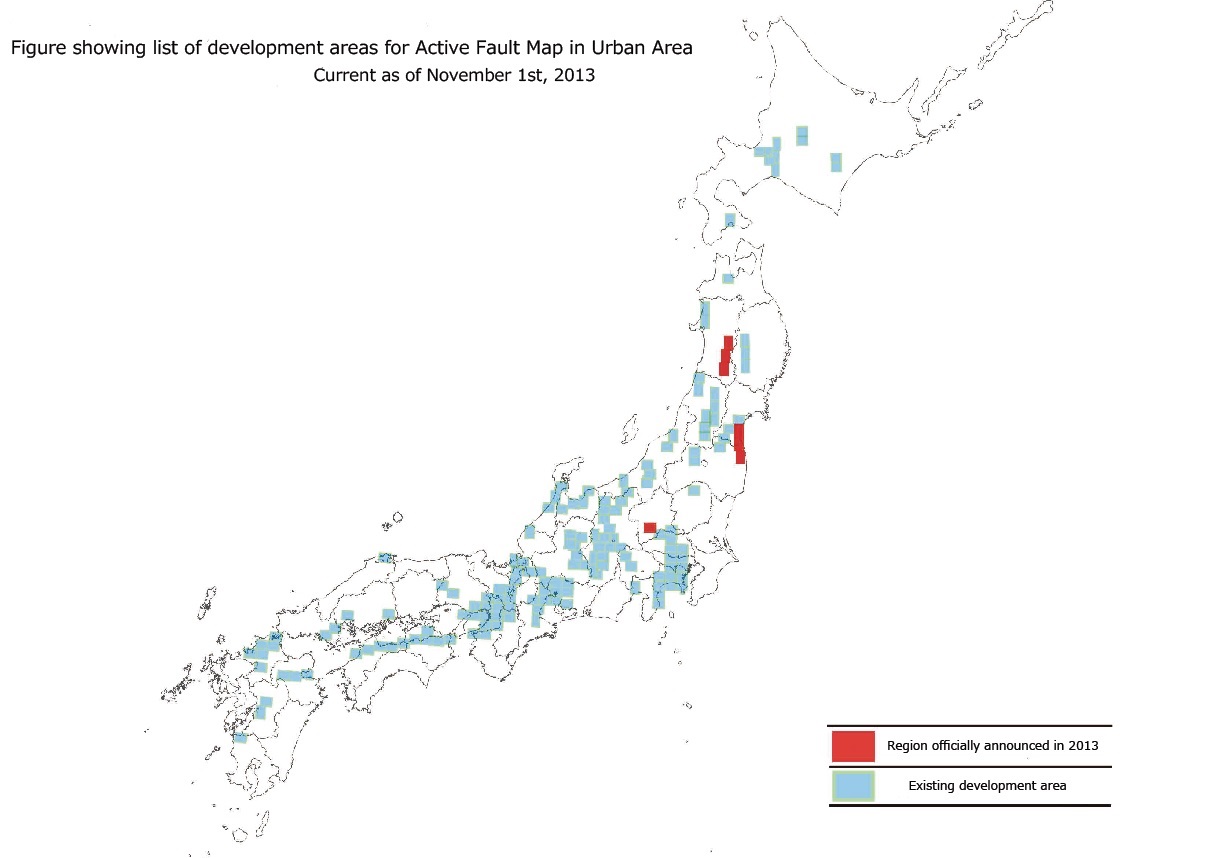
These maps are expected to serve as basic materials for disaster prevention/reduction and suitable regional development/conservation implemented by national administrative organ and local governments, such as in the production of regional disaster prevention plans and hazard maps.
Access to the MapsThe Active Fault Map in Urban Area can be browsed under “GSI Maps” on GSI homepage. For further details, please see the following webpage.
GSI Maps(in Japanese) The Active Fault Map in Urban Area is 1,000yen (including tax) per one sheet, and available at books stores that deal with maps nationwide. Things gained from this survey1. “TAZAWAKO”, “YOKOTE” and “YUZAWA” (in the Eastern Boundary Fault Zone of the Yokote Basin and its vicinity) These maps show Obonai Fault (10.4km), Shiraiwa Fault (14.2km, Ota (5.3km), Sen’ya Fault (14.0km), Kanezawa Fault(9.9km), Sugisawa Fault (3.7km), Yokote Fault (12.3km), Akasaka Fault (7.1km), Omori Yama Fault (14.7km), Higashi Chokai San Fault (15.6km), and other active faults/presumed active faults. (Note: Fault lengths are within the range shown on these maps.)
[1] The Shiraiwa Fault is a dip-slip* fault dipping on the West side and extending from Tazawakosotsuda in Senboku Shi to Otamachiota in Daisen Shi. In this survey, the section stretching northward from Tamagawa for approximately 2km was recognized as an active fault (Attachment 2-A). This survey also recognized the two faults dipping on the West side of this fault as active faults (Attachment 3-A, B). [2] In the existing “New Edition: Active Faults in Japan” (Active Fault Research Group, 1991), the Higashi Chokai San Fault was shown in the section from Maemori 3-chome to Aikawahumoto in Yuzawa Shi, but in this survey it was recognized as an active fault extending on the North side from Iwasaki to Maemori 3-chome and on the South side from Aikawahumoto to the area of Takamatsu Gawa in Yuzawa Shi (Attachment 4-A, B). 2. “WATARI”, “SOUMA” and “MINAMISOUMA” (in the Futaba Fault Zone and its vicinity) These maps show the Futaba Fault Zone (approximately 66km) and other active faults/presumed active faults. (Note: Fault lengths are within the range shown on these maps.) 3. “TAKASAKI” (in the Northwestern Boundary Fault Zone of the Kanto Plain and its vicinity ) This map shows the Fukaya Fault (20.1km), Isobe Fault (4.3km) and other active faults/presumed active faults. (Note: Fault lengths are within the range shown on these maps.)
[1] The Fukaya Fault is a dip-slip* fault dipping on the Northeast side extending from Nakamuroda to Negoya in Takasaki Shi. Fukaya Fault in this map is largely split into three sections. 1) On the North side from Iwashiro to Shobuzawa in Takasaki Shi (2.5km), places with active flexure* can be seen in the dip-slip fault recognized to be dipping on the Southeast side in a North-Northeast/South-Southwest direction. This part has been newly recognized as an active fault in this survey. (Attachment 7-A) 2) Two to four almost parallel fault lines have been recognized from Yanaba to Kamitoyookamachi in Takasaki Shi (11.3km), diverging into two lines around Shimosatomi, and parts with flexural displacement can also be seen. (Attachment 7-B) 3) On the South side from Notsuke to Negoya in Takasaki Shi (6.3km), it has been recognized that there is a dip-slip fault dipping on the Northeast side. The Fukaya Fault to the South of Negoya is shown in the “Honjo/Fujioka” map. (Attachment 7-C) [2] The Isobe Fault is a dip-slip fault that dips on the Northwest side extending from Shozen in Annaka Shi to Dainichi in Tomioka Shi. The fault is concealed from Hyuga to Shinchi in Annaka Shi. (Attachment 7-D) (For items marked with a *, refer to “7. Explanation of terms” in Attachment 8) AttachmentsAttachment 1: Figure showing areas for making of “Active Fault Map in Urban Area”
Attachment 3: Part of “TAZAWAKO” and “YOKOTE” [PDF 327KB] Attachment 4: Part of “YUZAWA” [PDF 301KB] Attachment 5: Part of “WATARI”, “SOUMA” and “MINAMISOUMA” [PDF 209KB] Attachment 6: Part of “MINAMISOUMA” [PDF 330KB] Attachment 7: Part of “TAKASAKI” [PDF 449KB] Attachment 8: About National Active Fault Zone Information Development (making of “Active Fault Map in Urban Area”) [PDF 154KB]  Some files are available in PDF format. To view PDF files, Adobe System's free "Adobe Reader" software must be installed. Please visit the following link to download the free software. |