

Emergence of South Pagai Island Observed by SAR
|
Released:2007.10.02 Last update: 2007.10.08 JAPANESE 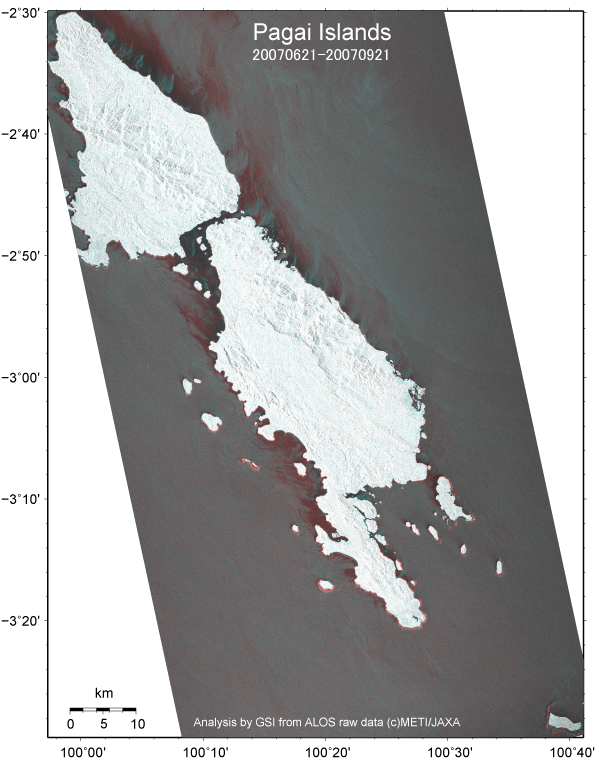
These images are derived from a comparison of intensity of reflected microwave observed by Daichi PALSAR between June 21, 2007 (before Earthquake) and September 21, 2007 (after Earthquake) to investigate the position of earthquake source fault of the September 12, 2007 Sumatra Earthquake (Mw8.4).
The intensity depends on the roughness of earth surface. The intensity images are represented in black-to-white (high intensity) grayscale. Ocean with no wave is usually represented in black or dark gray in intensity images. The color of the grayscale intensity image before the earthquake was converted to black-to-cyan cyanscale. The color after the earthquake to black-to-red redscale. An additive color process of these two images in cyanscale and redscale produces a change map. Area, where there is no roughness change, is represented in grayscale, because the additive process between cyan and red results in white. Cyan means decreasing of intensity (i.e., roughness) due to e.g., subsidence in the change map. There is no cyan in this image. Red corresponds to increasing of intensity (i.e., roughness) due to e.g., emergence (uplift). Red ribbons in southern part of South Pagai Island (Pulau Pagai Selatan) are due to uplift by the coseismic fault slip. The reflection intensity in the ocean depends on incidence angle of the radar, polarization of the microwave and ocean wave (i.e., roughness). Red and cyan areas in the ocean are due to difference in these three factors. We switched the color notation of "Coastal Changes due to Uplift and Submergence caused by 2004 Indian Ocean Earthquake, in Andaman Islands, Nicobar Islands, Sumatra, and Simeulue island" (Red: submergence, Cyan: emergence) to the notation of this report (Cyan: submergence, Red: emergence). [The Relation with the Earthquake Fault] The fact that only the southern part of South Pagai Island uplifted implies that the earthquake fault located near this region, where is about 150 km from the epicenter. These kind of emergence/submergence images are useful for estimating the position of the earthquake fault. [Difference in Tide Level] The difference of tide level at the acquisition time of the SAR data is only 2 cm, which is ideal for this kind of study. Magnified Image of South Pagai Island (Pulau Pagai Selatan)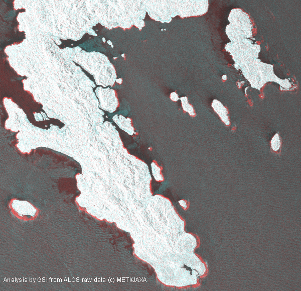
2007 earthquake pushes up cluster of 6 new islands.
The emergence had increased the size of small islets and even produced more than six new small islets. The length of the maximum islet is approximately 1.6 km. Up to 500 m wide emergence of reef is seen in the bottom left island in this image. The edge of the source fault is probably located near here. Satellite and SensorPALSAR sensor onboard "Daichi" (ALOS) satellite launched by Japan Aerospace Exploration Agency on January 24, 2006
|