-After approximately 2 years and 3 months since the previous slow slip event occurred offshore of the Boso Peninsula-
Outline
Crustal movement different from the normal and steady movement in the Boso Peninsula has been detected in data observed at GNSS-based control stations since approximately January 2
nd, 2014. To date, this nonsteady crustal movement reached approximately 1cm at maximum.
It is inferred from this movement that a “slow slip event” is occurring beneath the sea offshore of the Boso Peninsula on the plate boundary surface* between the Philippine Sea plate and the continental plate. The estimated slippage from the nonsteady crustal movement ranges up to approximately 6cm
off the Boso Peninsula.
*This boundary surface is different from the boundary surface between the Pacific plate and the continental plate, which caused the 2011 off the Pacific coast of Tohoku Earthquake.
Details
- The slow slip events have been repeatedly observed in roughly the same area by the GNSS-based control stations in May 1996, October 2002, August 2007, and November 2011. The intervals between these events were 77 months, 58 months and 50 months, respectively, but the interval between the previous event and this new event was 27 months, which was the shortest interval since GNSS observations started in 1996. The durations of the slow slip events in the area were approximately 10 days for the past cases.
- Moreover, this nonsteady crustal movement is still ongoing. Therefore, the analysis results that have been obtained this time are provisional at best, and information may be updated to reflect the accumulation of the data and further inspection of them.
- Geospatial Information Authority of Japan (GSI) will continue to carefully observe this irregular crustal movement.
※The provisional analysis results are available to the public in materials published at the following Press Release page (Japanese only).
http://www.gsi.go.jp/WNEW/PRESS-RELEASE/chikakukansi_boso20140102.html
Supplementary explanation
Plates around the Japanese archipelago
- In the Japanese archipelago and its surroundings, there are the Pacific plate and Philippine Sea plate on the ocean side, as well as the plate on the continental side, and it is known that these plates are getting closer to each other.
- The Pacific plate is getting closer to the plate on the continental side from a roughly East-Southeast direction at a rate of approximately 8cm per year, and is sinking beneath landside plates in the Japan Trench and elsewhere. The Philippine Sea plate is getting closer to the Japanese archipelago from a roughly Southeast direction at a rate of around 3 to 7cm per year, and is sinking beneath landside plates in the Nankai trough and the Sagami trough.
- The slow slip event detected this time in the sea offshore of the Boso Peninsula occurred at the boundary surface between the Philippine Sea plate and the continental plate that sinks from the Sagami trough. This boundary surface is different from the boundary surface between the Pacific plate and the continental plate that sinks from the Japan Trench, which caused the 2011 off the Pacific coast of Tohoku earthquake.
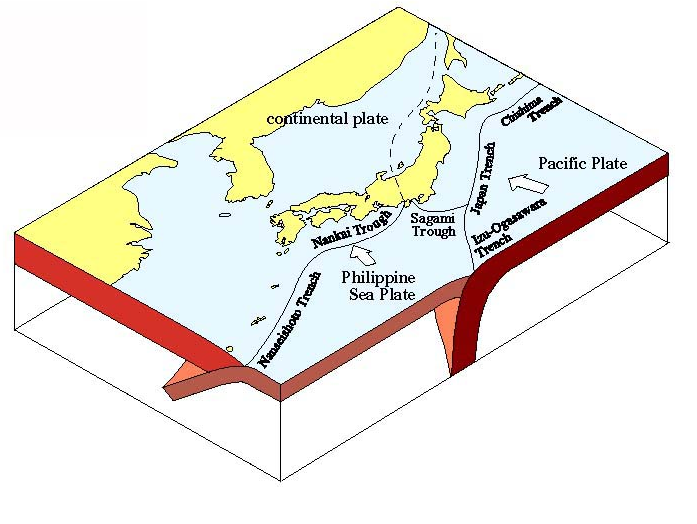
Plates in the Japanese archipelago and surrounding area.
(from “Seismic activity in Japan – regional perspectives on the characteristics of destructive earthquakes” (The Headquarters for Earthquake Research Promotion))
Slow slip event
Slow slippage at a fault surface or plate boundary surface, and that does not emit seismic waves.

