

Crustal Movement in Japan
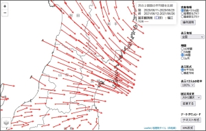
Crustal Movement in JapanAbout Crustal Movement in JapanGeospatial Information Authority of Japan(GSI) has established GNSS-based control stations throughout the country. About 1,300 control points have been set up as of today, and are distributed at an interval of about 20km. They are used for surveying, researches for earthquakes and volcanic eruptions. These points enable us to monitor crustal movement in real time.
Information on Crustal Movement(Updated every Tuesday) In this page, you can see the vector map and the time series graph of crustal deformation of the past 1 month, 1 year, 5year and 10year. And also you can download files of the numeric data.
 Animation of Crustal Deformation in JapanThis page shows the crustal movementinanimation
 Links
Contact UsGeodetic Observation Center, Geospatial Information Authority of Japan(GSI)
 |